The area of Bona Bornia or BonaBonner
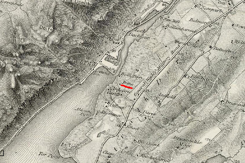
Bona Bornia is not a real place in Scotland. First, Bornia is not really a Scottish name, Bona is, it is an ancient town close to Inverness on the northern end of Loch Ness. A ferry, lighthouse, cottage and lodge are there, and supposedly an old cemetary of the town. Another variation I have seen is Bona Bonner, still no help. There are several names that are close to Bona Bornia. Recently I saw some questions from George McKinniss that prompted me to look at another variation. A barony is a region of land, often given to Barons of the area. There is an area called barony of Bona, or Bona barony, that is the closest phonetic name to Bona bornia.
Here are the current theories as to the town or area that Charles was from.
1) Bona barony, or barony of Bona2) Barony near Glasgow
3) Bona banatia
4) Bonnybridge area
5) bonny burn
After Culloden, General Braddock had permission to recruit more people for his U.S. campaign. Braddock did not fight in Culloden but the 48th Regiment did fight at Culloden, and Culloden is not that far from the Inverness (Bona) area. The 48th Regiment was called Conway's Regiment at Culloden. I need to do more research, but I think there was a fort between Edinburgh and Glasgow that housed these troops before sending them overseas. Most troups were sent out of Ireland in the town of Cork. More of this story below.
1) Bona barony
According to Wikipedia, a barony is "A barony is an administrative division of a county in Scotland, Ireland and outlying parts of England. It has a lower rank and importance than a county." Lands were often granted to Barons of the area, and this naming is consistant with the time.
In the Google book "Invernessia contributions toward a history of the town." on page 22. 23 talks about the area of Bona. On page 24, it lists a description of the barony of Bona: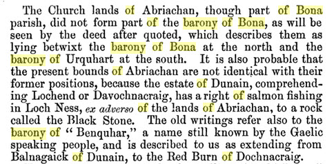
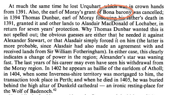
In another book, the actual name of Bona barony was named. Interesting, this was a book on The Wolf of Badenoch - Alexandar (Stewart) Grant.on page 154 The timeline here is about 100 years after Andrew (Stewart) Grant, so this Alexander may have been a son or a cousin of Andrew. Andrew may be our forefather back to 1292. He was a Stewart who became a Grant. More on this in the Andrew Grant section. But Andrew was from the area of Stratherherrick and Ballachastle, which is an area just below Bona on Loch Ness. I also have many Grants from that area of Inverness, thus lending credence to the Grant connection and Bona location.
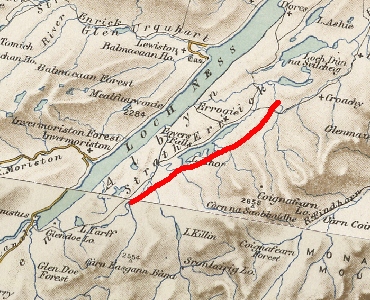
The location of Stratherrick or Ballachastle, a place that no longer exists, is on Loch Ness. These places are mentioned in the Andrew Grant documents. Strathherrick is described as "Stratherrick of Invessness Shire". If Andrew Grant was a forefather, having family spin offs in Bona would be logical. The barony of Bona would probably be to the north and slightly west, next to the Urquhart area. The Urquhart Castle is a Grant castle.
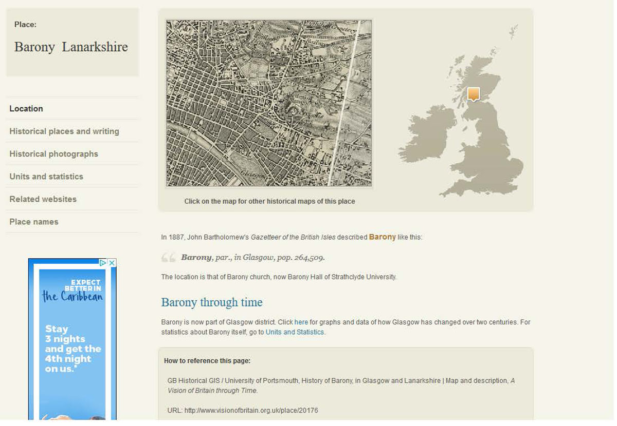
2) Glasgow Barony
This Barony has a formal name, I did not see it listed as barony of Glasgow This region looks to be inside of Glasgow. It was later incorporated into Glasgow. From the Visit Britain maps is a picture. This area is a little hard to see, added for reference. Not sure where the Bona part would come from, maybe bonny meaning pretty. It fits the description of "(between Glasgow and Edinburgh". But if Barony is going to be for bornia, the Bona barony name fits better.
3) Bona Banatia
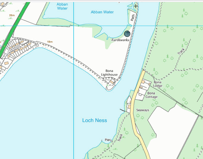
Bona is an ancient town just south of Inverness of which the Bona Lighthouse still stands. Banatia is the name of the Pictish town, later named by the Roman's as a Roman Station. Below is reference to that location.
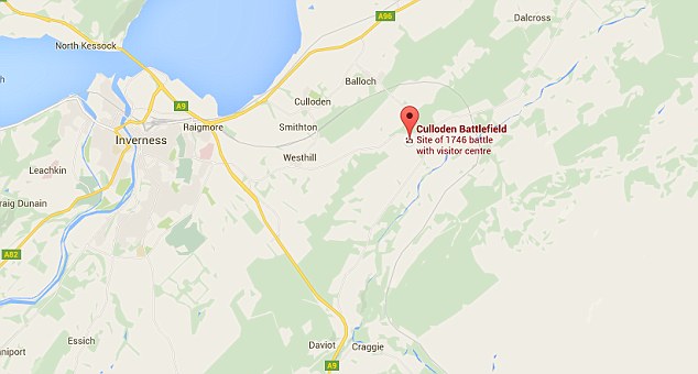
Prince William, the Duke of Cumberland (nicknamed Butcher Cumberland for his battlefield tactics) named General Braddock as the head of all crown forces in America, and Culloden moor is just a few kilometers (about 20 or 12 miles) from this area. Braddock was at Culloden but did not fight. Prince Charlie also came up from Fort Williams and would have passed very close to Inverness. So there are several ways Charles at 22 could have been forced into the British Army.
If Charles was from the Bona area, General Wade's Military Road passes right next to Bona. Charles should have been impressed in 1744, but the dates could be off. He may have joined Prince William, Culloden was April 1746. Or been impressed into Cromwell's milita a few years before Culloden. Charles does not seem to be in any of the musters for either side.
Map from dailymail.co.uk
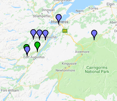
Lastly, the DNA results for McKinnis are closer to the Grant line, see the DNA section below. Many of these DNA matches show up around Inverness and down to Fort Williams.
This map is for 37 marker matches, which is reasonably high match.
Some more background of sources for the Bona area.
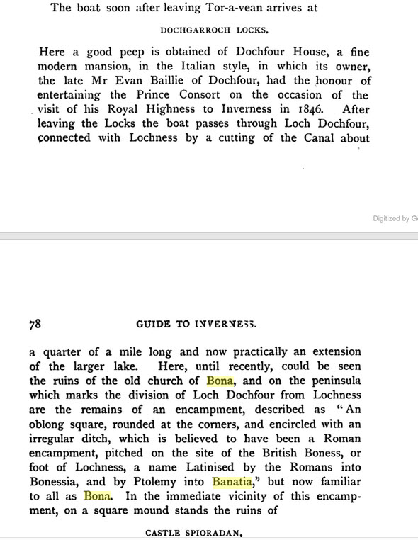
Alexander MacKenzie's "Guide to Inverness" refers to the Bona area and the Roman Station name Banatia or Bonessia.
Another reference is "Transactions, Volume 18" by Gaelic Society of Inverness that talks about a Pictish town of Banatia in the district of Vacomagi as mapped by the ancient geographer Ptolemy. This later became Bona of Inverness.
This excerp from MacKenzies book.
Another description of the Bona area.
http://www.visionofbritain.org.uk/place/21983
In 1882-4, Frances Groome's Ordnance Gazetteer of Scotland described Bona like this:
Bona, an ancient parish of NE Inverness-shire, now united to Inverness parish. The central part of it is at Bona Ferry, on Loch Dochfour, 6 miles SW of Inverness. A school-house, used for religions service, the ruins of the ancient church, and remains of a ` Roman station,'formerly identified with the Banatia Urbs of the false Richard of Cirencester, are in the vicinity of the ferry; and a rude mediæval fortress, called Castle Spiritual, and probably designed to command the passage of the Ness, stood near the site of the ` Roman station, ' and was partly removed in operations for improving the Caledonian Canal. ...
During the progress of these operations, at and near the fortress there were found some coins of Queen Elizabeth, a number of well-preserved human bones, a complete human skeleton, and a stone-encased nest of live toads.
From the Canmore web site https://canmore.org.uk/event/661307
Event ID 661307
Category Descriptive Accounts
Type Archaeology Notes
Permalink http://canmore.org.uk/event/661307
NH63NW 2 6027 3796.
(NH 6027 3796) Site of the Roman Station called Banatia {R}
OS6"map, Inverness-shire, 2nd ed., (1905)
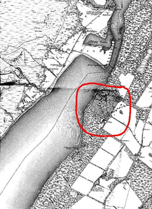
On the flat gravelly peninsula which divides Loch Ness from Loch Dochfour, are traces of a small Roman encampment. It is an oblong square, rounded at the corners, and encircled by ramparts of earth, and an irregular ditch, from twenty to forty feet wide. On a square mound, closely adjoining stand the ruins of an old baronial keep, called Castle Spiritual.
G and P Anderson 1847; NSA 1845. (A Rose, A Clark and R Macpherson)
On this peninsula there has been a military station of two small forts. The outer fort is a square of 50 paces by 53, which on the one side is protected by the river, and on the other by the small loch; and, next the field, it has a ditch and rampart. On the inner side of the peninsula is another rampart and ditch. The other square fort, 24 paces square, has rather the appearance of being built with modern masonry Grant 1822.
The Roman camp is said to have been in a good state of preservation until the Caledonian Canal was deepened, when the ditch surrounding it was filled in, and the ground where the camp stood cultivated.
Name Book 1870.
The two small square forts at Bona are evidently not Roman.
O G S Crawford 1947; Chalmers 1807
No earthworks exist at this site - now a cultivated field.
Visited by OS (J L D) 21 March 1962.
No change
Visited by OS (N K B) 23 January 1970.
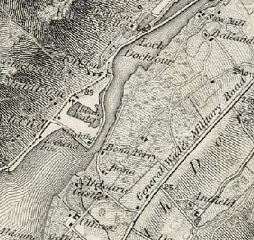
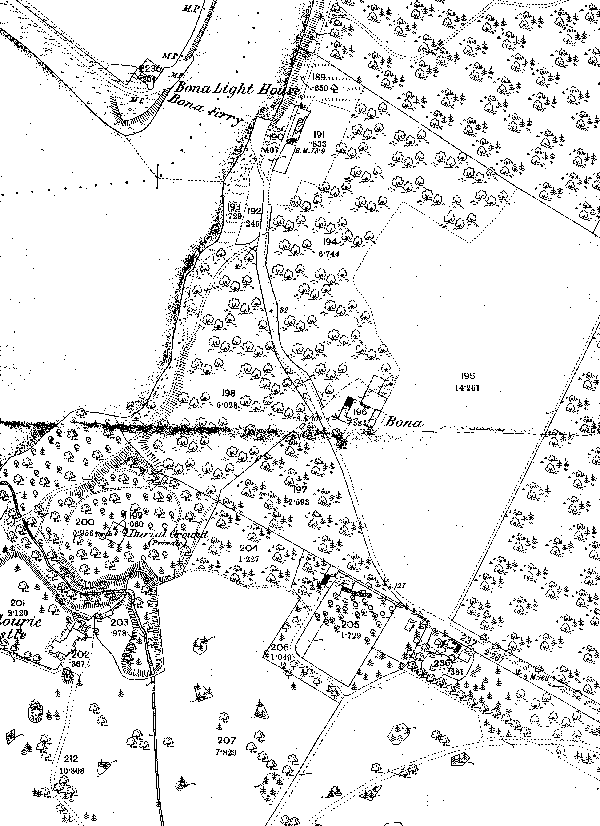
Maps of the town of Bona and surrounding area
https://canmore.org.uk/site/13170/bona
Below: © Copyright and database right 2016. All rights reserved. Ordnance Survey license number 100057073.
4) Bonnybridge. This is located slightly north and east of Glasgow and north and west of Edinburgh. There is also the town of Bo'ness just to the east on water.
One possibility was put forth by our Clan MacInnes colleague in Scotland. The people of an area were known as Bairnes. So Falkirk Bairnes are the people from around Falkirk. Bonny Bairnes, or Bo'ness Bairnes are possibilities.
Also information from Wikipedia about Bonnybridge whichis also shown below in the bonny burn area.
https://en.wikipedia.org/wiki/Bonnybridge
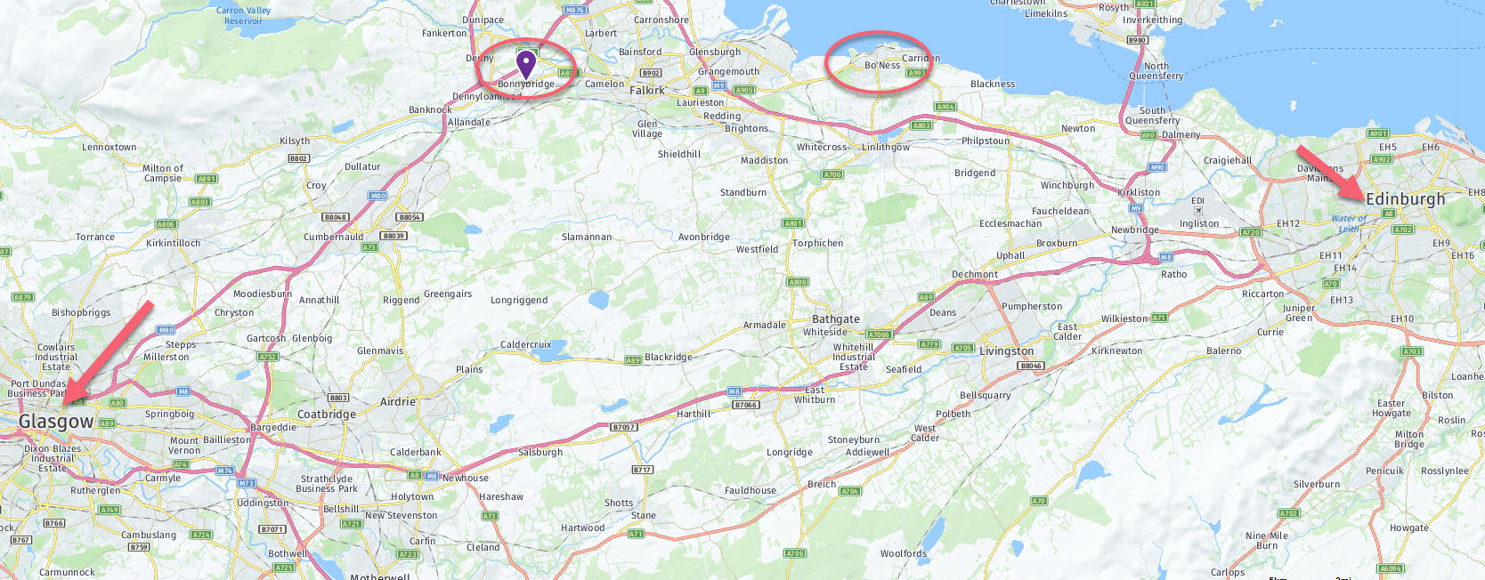
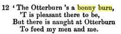
5) bonny burn - a small or reasonible sized stream. This name found in several very old poems so it could be any area close to a stream. Or it could be near Bonnybridge again where the stream is called Bonny Water.
This poem excerpt if from "English and Scottish Popular Ballards" Volumn 4, edited by Francis James Chile.
The Battle of Otterburn.
This term seems popular around 1300 to 1600.
Also some information from Wikipedia about Bonnybridge. But the river is normally called the Bonny Water, not Bonny burn.